
Cycling California’s Royal Road (the El Camino Real) is an 800-mile (1,287 km) epic adventure not considered lightly.
The appeal of visiting picturesque missions established by Spanish priests between 1769 and 1823 and touring a route through California that still looks very much like it did back then is why it’s done.
The missions are from 16 to 60 miles apart (26 to 97 km), distances that test the limits of the endurance and ability of most cyclists or walkers. So too, pacing oneself, and timing rest stops and lodging requires forethought and guidance.
There are no commercial tours organized for the mission cyclists. Sandy Brown’s guidebook (cited in Part I) and Butch Briery’s California Mission Walk: The Hiker’s Guide are considered the best mission trail guidebooks but Meredith Cherry’s “Along the King’s Road: … California Missions by Bicycle” and Edie Littlefield Sundby’s “The Mission Walker,” also have great value. A website managed by the California Mission Walkers and their private Facebook group all specify what roads to take, where lodging is found, how to prepare and what to take along.
This is not like the Camino de Santiago in Spain where every community and business along the route expects pilgrims. The El Camino Real passes through largely open country with no directional signs and few services. You must make your way much as the padres did.
Cyclist Richard Scholl recommends referring to Google Maps on a smart phone, mounted to handlebars, for cycling directions and suggests Warm Showers, a network of cyclists who host riders overnight. Some riders and walkers choose to be accompanied by a ground crew that drives ahead and can transport them and their bike when the ride takes longer than expected.
On those long days, thoughts turn inevitably to those who first traveled it. Sundby, who walked its length after defeating stage four cancer, said you, “truly understand, as close as you possibly can what they experienced. It’s a wide-eyed wonder.”
On the pedal south from Mission Soledad to Mission San Antonio (50 mi/ 4.2 hrs.), there’s time to reflect on that. The path leads up out of the Salinas Valley along the eastern foothills, past Pinnacles National Park where critically endangered California Condors – the largest land birds in North America – ride thermals into a blue sky.
Continuing from the Salinas Valley into the Santa Lucia Mountains, the Jolon Grade climbs gradually on an easy pedal through blue oak woodlands and past wild grassy ranchlands. This was once a stage route between San Francisco and Los Angeles, though it is lightly traveled today.
The last six miles of the route pass through Fort Hunter Liggett, the U.S. Army Reserve’s largest training facility. The combination of a long ride from U.S. 101 and that it lies six miles beyond the entrance to a U.S. Army fort, often discourages travelers from visiting Mission San Antonio, though it is not to be missed.
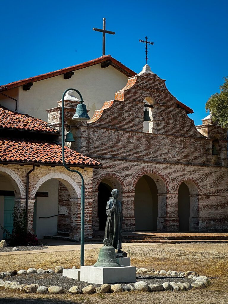
When Franciscan priest Junípero Serra first traveled north to Monterey, he noted the large number of tribes living in the area and vowed to return to establish a mission there. Two years later in 1771, he founded La Misión San Antonio de Padua (Mission Saint Anthony of Padua), the third of California’s missions and the first without a presidio.
Mission San Antonio’s campanario, or bell tower, provides a beautiful entrance to the mission. Photo by John Poimiroo
Seen at the base of distant oak-flecked hills, Mission San Antonio, named after the patron saint of lost things, was subsequently lost to time. According to Mission walker Jerry Edwards, “Arriving at Mission San Antonio, the most untouched of all the missions, is probably what Fr. Serra would have seen.” Before its descent into obscurity, this enormous mission was one of the largest and baptized 1,000 people. Being so little known today, the church’s enormous size is an unexpected surprise.
Serra had insisted that there should be no substantial military presence at San Antonio because Spanish soldiers were abusing Indians at other missions. So, only a small guard was posted there. Ironically, the mission is now surrounded by soldiers from Fort Hunter Liggett whose presence assures its protection.
A bell wall (campanario), separate from the church’s facade, and a long cloister along the front of the quadrangle provide a classic entrance to the mission. The church is one of the best maintained and interpreted of California’s missions, which is remarkable, considering it only has a staff of three.
Misión San Antonio de Padua is one of the best maintained and interpreted of California’s missions, which is remarkable, considering it only has a staff of three. Photo by John Poimiroo
Inside the quadrangle a superb museum demonstrates mission life. The mission’s landscaped courtyard displays Indian grinding stones and a burbling fountain, none of which were original, as the quadrangle was a work area during the day and stabled animals at night.
Guests can sleep like a Franciscan padre at Mission San Antonio de Padua, the only mission that accepts overnight guests. Modern guest rooms, furnished comfortably but simply, have been created for spiritual retreats. Anyone who expresses a personal “spiritual” or “educational” reason for visiting can stay there but advance reservations are required (office@missionsanantonio.net). Cost; $60/night/retreatant (closed Sun. – Tues. nights). Greatest availability is Wed – Thurs. nights (cap. 65).
Administrator Joan Steele says San Antonio’s guests are awed by its quiet and solitude. The rooms are furnished with single beds, a private sink and outfitted with fresh linens and towels. There is a microwave and refrigerator, but cell phone coverage is limited and there is no Wi-Fi.
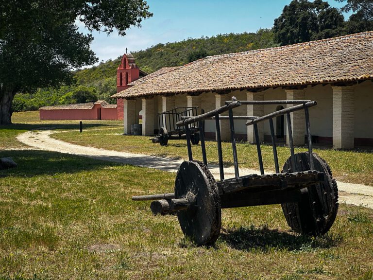
The North River Road leads from Mission San Miguel through Paso Robles wine country. Photo by John Poimiroo
The cycling distance from Mission San Antonio to Mission San Miguel takes 5.6 hours and much of it passes through 41 miles (66 km) miles of vineyards. At U.S. 101, straddling the highway is Camp Roberts where the California National Guard trains. An Historical Museum, open free on Thursdays and Saturdays, tells the camp’s story, including the many celebrities who trained there during WWII.
The camp’s military history dates to the late 1700s when Spanish soldados de cuera (leather jacket soldiers) scouted Mission San Miguel’s vast domain. In 1769, Gaspar de Portolá reported seven Salinan villages near where La Misión San Miguel Arcángel (Mission Saint Michael the Archangel) was eventually located. While high on Fr. Serra’s list to be the location of a mission, it wasn’t until 1797 that Fr. Fermin Francisco Lasuén – Serra’s successor – established California’s 16th mission there.
Mission San Miguel grew quickly. Within nine years, it numbered 1,000 residents. However, by 1831, imported European diseases had reduced the population to 700. The padres fretted about losing their flock, exasperated by what was causing the illnesses of so many people under their care and protection.
The sanctuary inside Mission San Miguel once served a congregation numbering over 1,000 worshipers. Photo by John Poimiroo
Though its people were destructible, the mission survived. Mission San Miguel was largely spared the erosion that washed away church walls at other missions after they were abandoned. Frescos painted on its interior by mission Indians under the direction of artist Esteban Carlos Munrás still retain their bright colors and are the best-preserved murals painted by native people at a California mission. Above the altar, a statue of St. Michael the Archangel and an intimidating, three-dimensional depiction of the all-seeing eye of God dominate the church.
The mission’s original ground-level bell wall is found in the mission cemetery. The mission’s most striking campanario can be seen from U.S. 101 at the south end of the mission grounds. It was erected in the 1950s to honor Franciscan priest, Fr. Fidelis Wieland, the mission’s former pastor who was killed in action while serving as a Navy Chaplain during WWII.
Like at other California missions, a museum fills rooms in the quadrangle that once housed candle-making, leather-working, weaving and dormitories. Bright red, yellow, and blue frescos frame windows in the mission’s courtyard, happy nods to its time of Californio vaqueros, fiestas, fandangos, and bull fights. The gurgling splash of a fountain is the only sound remaining in what was once a bustling gathering place for mission Indians.
The gurgling splash of a fountain is the only sound remaining in what was once a bustling gathering place for mission Indians. Photo by John Poimiroo
The El Camino Real was once identified by crosses carved by Spanish soldiers into the trunks of oak trees. After an ancient oak fell near Paso Robles it split in half revealing one of those crosses. The relic is now displayed inside the museum at San Miguel.
In 1833, concerned that Franciscan priests remained loyal to Spain, Mexico secularized the missions and shut them down. At San Miguel, those remaining Salinan people returned to their ancestral grounds, mission lands were divided into land grants and Mission San Miguel became the home of the William Reed family.
With the collapse of Mexican authority, California became the wild west. In December of 1848, bandits murdered the Reeds and raided their household for their few possessions. A posse eventually tracked the desperados to Santa Barbara where they were captured and executed by a firing squad near the old presidio.
Mission San Antonio’s mission walls still stand after the passage of more than two centuries during which there have been prolonged lapses in maintenance. Photo by John Poimiroo
The escape route the bandits took is the same cyclists take through Paso Robles and Templeton and over Cuesta Pass to San Luis Obispo. It follows one traveled by legendary frontiersman James Pierson Beckwourth who, while carrying the mail, discovered the massacre.
From San Miguel, it’s 43 mi/69 km to San Luis Obispo (est. 4 hrs), starting on North River Road which dips and swirls beside landmark oaks, farmlands, orchards, cattle ranches, vineyards and over hills. The road soon enters the Estrella district of the Paso Robles American Viticultural Area (AVA). There are more than 250 wineries in this premier growing area, renowned for its Bordeaux and Rhone-styled wines.
At Hearst Ranch Winery, it’s a quick dismount from cycling and you’re tasting (Thursday – Monday, 11 – 4) the winery’s delicious wines. The Hearst name is common in the area, as newspaper scion William Randolph Hearst built the Hearst Castle (just over the hills on the coast) and once owned vast land holdings throughout the region.
Directly across from the Hearst Ranch Winery is La Hacienda a mid-1800s adobe farmhouse whose thick walls naturally cool the hacienda. It has been modernized into a luxury 4-bedroom, 4-bath vacation rental with a gourmet kitchen. Photo by John Poimiroo
Directly across from the winery is La Hacienda a mid-1800s adobe farmhouse whose thick walls cool the Hacienda naturally (it also has air conditioning). It has been modernized into a luxury 4-bedroom, 4-bath vacation rental with gourmet kitchen, hot tub and is tastefully decorated in festive Mexican villa style with bold colors and textures. In a few rooms, remnants of the original adobe brick are left exposed, which emphasizes the reality of the old adobe. La Hacienda is a great choice for four teams of riders, though at $795 a night and a 2-night minimum, it would be pricey for one or two guests.
The California Mission Trail continues to twist and turn through wine country and past Paso Robles before turning south near U.S. 101 to Templeton Road. While Paso Robles is edgy and hip, Templeton feels more like an old west town.
Leaving the Salinas Valley, you ride through Atascadero and onto the old El Camino Real before Santa Margarita and the climb over Cuesta Pass. The trail then descends 1,200 exhilarating feet down the gravel-surfaced Old Stage Coach road (1876), with breathtaking views of the San Luis Obispo Valley.
Junípero Serra remembered that when he passed the valley in 1769, Gaspar de Portolá had noted the great number of grizzly bears roaming in it. So, when food was running out at Mission Carmel, Serra dispatched hunters there. They returned with bear meat and stories of the Chumash people; a peaceful people known for their hospitality. A year later (1772), California’s fifth mission was founded at San Luis Obispo.
California’s Indians had, for the most part, inviting societies that welcomed visitors. They were not warlike; their weapons were designed for hunting, not fighting. California had bountiful sources of food, so its native people did not cultivate much and stored little but acorns. They survived on hunting and gathering. Their foods (insects, shellfish, acorn mush, berries, greens, fish and small game) were alien to farming and ranching Spaniards.
Three hundred languages were spoken by California Indian tribes, which attests to their isolation from one another. This made it difficult for the padres to communicate in places where they’d not yet learned the local tongue. That meant, each new mission took years to establish a community. Transgressions by individual padres, Spanish soldiers or authorities did not occur without retribution. On several occasions the largely peaceful Indians fought back.
La Misión San Luis Obispo de Tolosa (Mission Saint Louis of Toulouse) was the second to be roofed with baked tiles (Mission San Antonio was the first) after an Indian’s flaming arrow set its original thatch roof afire. Thereafter, it expanded to several structures including a mill and granary, quadrangle, workspaces and living quarters, and was successful for many decades.
Following secularization, people left the mission complex which quickly fell into ruin. State Park Interpretive Specialist Leah Braitman explained, “There was a lot of despair (among the Indians after missions closed). Because they couldn’t go home … back to their traditional way of life. It had changed forever.”
La Misión San Luis Obispo de Tolosa survived an Indian attack to become one of the Franciscans most successful missions. It fell into disrepair following the secularization of the missions, but today following decades of restoration is one of the most beautiful. Photo by John Poimiroo
A few of San Luis Obispo’s buildings survived and were used for commercial purposes, while the pueblo became lawless. Years later, the mission church was rebuilt to resemble its original form. Several of the original mission buildings remain in town. One of them, now a woman’s clothing store – named Maison Marianne on Chorro St. – has the classic, deep-set windows, and white exterior walls of a mission adobe, though one wonders what the padres would say about its contemporary use.
Many consider Mission San Luis Obispo’s church to be one of the loveliest in California. It is decorated with early 19th-century frescos of garlands laced with wildflowers, vines, doves, magpies, thrushes, and orioles arcing over niches, naves and alcoves containing statues of saints. In an alcove, a porcelain Pieta and cinnabar-colored floor tiles floor are illuminated by hundreds of devotional candles.
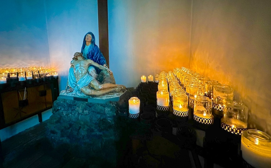
La Pieta statue atop a portion of the original stone wall is illuminated by dozens of devotional candles. Photo by John Poimiroo
At the back of the mission in what’s left of its quadrangle, the mission’s bells, “Gloria, Joy and Sorrow,” hang silently in a garden patio where parishioners gather following Sunday services. This is an active parish church with daily masses and tours of the church and a museum that contains relics of its past.
San Luis Obispo (SLO) is an ideal stop on trips along California’s Central Coast. It is halfway between San Francisco and L.A. and surrounded by the Paso Robles wine country, the Hearst Castle at San Simeon, Morro Bay, the artist community of Cambria and Pismo Beach with its sand dunes, amazing displays of tens of thousands of Monarch butterflies (Nov – Jan) and white, sun-drenched beaches.
Planning where to stay is an important consideration on this bike ride, as lodging is limited along the route. Not so in San Luis Obispo, which has a broad choice of accommodations, several designed to add to the visitor experience.
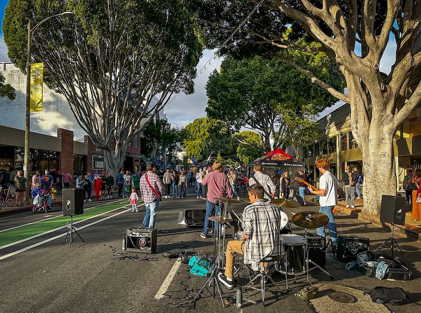
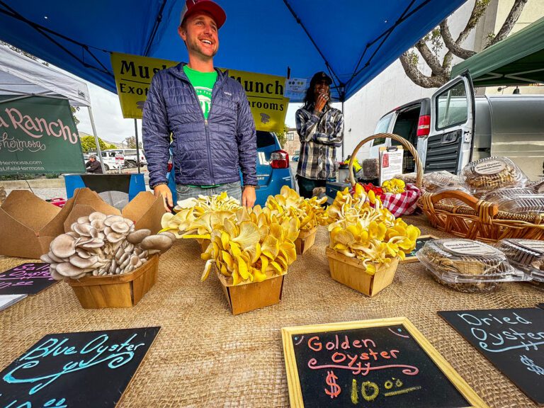
Every Thursday evening at 6 pm San Luis Obispo’s downtown Higuera Street becomes a Farmers’ Market. When the weather is good, student bands from Cal Poly fill the south end of the street where they compete for donations with jugglers and acrobats. Photo by John Poimiroo
The Apple Farm Inn resembles a spacious Victorian farmhouse. Guests are greeted with freshly baked chocolate-chip cookies, given complimentary wine tastings, and allowed to choose from 104 rooms, each with a gas fireplace and free Wi-Fi. There’s an onsite restaurant serving fresh farm-to-fork cuisine and baked goods. The inn’s marketplace features local flavors, artisanal goods, and handcrafted products straight from the farm.
Best known to Californians as home to California State Polytechnic University (Cal Poly), SLO has a college town vibe, right down to its bike-friendliness. Mission trail cyclists appreciate the SLO Bike Kitchen (860 Pacific St.), a do-it-yourself bike repair station, not far from the mission, where they can tune their bikes.
SLO’s community comes together every Thursday night at 6 p.m. on Higuera Street at the Downtown SLO Farmers’ Market. It got started 40 years ago following an effort by downtown merchants to curb cruising by teenagers. They reasoned if the main drag was closed for a family-friendly farmers’ market, the cruising would stop. It worked, and then some.
Between 3,000 and 10,000 now attend the Farmers’ Market spread over five blocks in downtown SLO. They visit stalls occupied by up to 120 vendors offering fresh produce, seafood, BBQ, delicacies, prepared meats, crafts, baked goods and street entertainment from jugglers and acrobats to musicians. There is also an annual egg-drop competition held among Cal Poly engineering students. The Farmers’ Market is one of the largest street fairs in the nation, a local point of pride, and listed by The Los Angeles Times as one of the top ten things to do in California. It is THE reason to time your trip to include a Thursday night in San Luis Obispo.
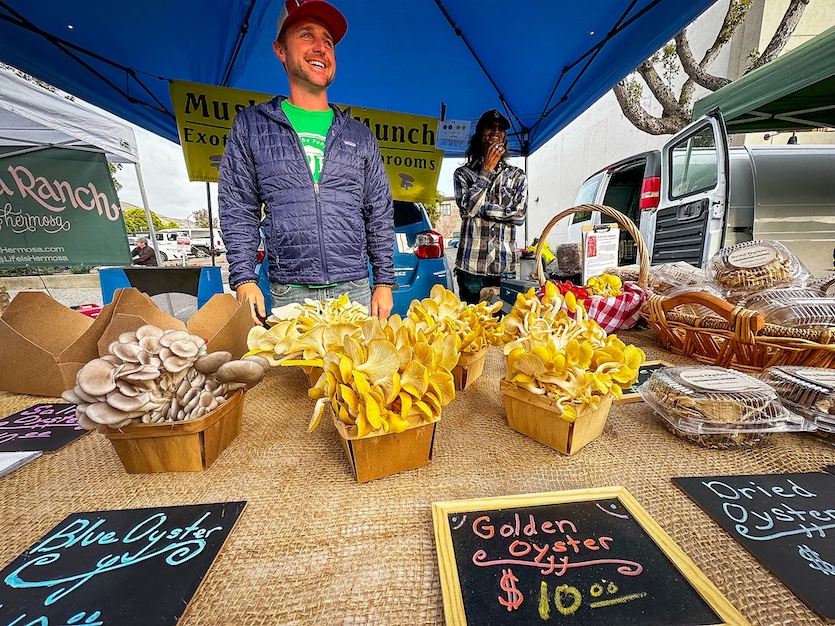
San Luis Obispo Farmers Market vendors sell a wide variety of local produce. Photo by John Poimiroo
From San Luis Obispo, you’ll be pedaling 58.8 mi/94.6 km (est. 5.25 hrs.) to La Purísima on the final leg of this section of the California Mission Trail. The first part of it is a descent to the Pacific Coast and Pismo Beach. Cyclist Bill Collins cautioned to be watchful of tourists driving Highway 1, as they are often distracted by the scenery. Pismo is a tantalizing siren that, like Greek mythological figures, lures voyagers to her long, broad beach of white sand that curves along the California coast.
The route then departs from the coast, heading inland toward Santa Maria (famous for its 150-year-old tradition of marinated tri-tip steak barbecued over oaken coals) and beyond, over rolling grassy hills and down the Harris grade to Mission La Purísima. For mission walkers like Jerry Edwards, surmounting rises like Cuesta Pass and the Harris Grade are what motivates them to do the Camino. “I love the hills,” he said, grinning.
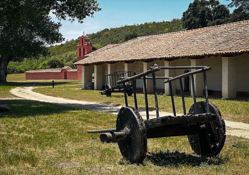
The original Camino Real used by Spanish friar Junipero Serra to connect his chain of nine missions runs directly past the front entrance to Mission La Pirísima. Photo by John Poimiroo
La Misión La Purísima Concepción De María Santísima (Mission of the Immaculate Conception of Holy Mary) was the 11th California mission (1787). Twenty-five years later, the mission was destroyed following a great earthquake, followed by torrential rains, trapping many residents inside its muddy quadrangle.
Its pastor, Fr. Mariano Payeras, directed that to avoid a similar fate, the mission buildings be rebuilt in one, long, wind-protected row with 4.5-foot-thick (1.4 m) walls and stone buttresses to resist the threat of future earthquakes. Mission La Purísima baptized 1,500, yet of all California’s missions, La Purísima has the most understated religious displays, perhaps because it is operated by the State of California.
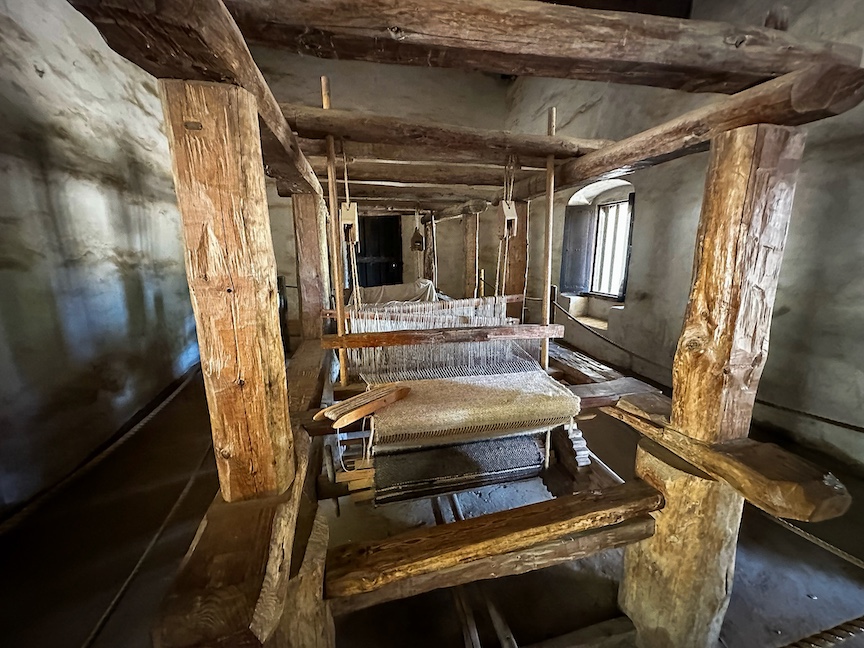
Weaving looms built to resemble those Indians might have used in the late 18th Century when Mission La Purísima housed a variety of cottage industries. Photo by John Poimiroo
Over 200,000 people visit La Purísima Mission State Historic Park annually, making it one of the most visited of California missions. It is also the most intact, with over 20 structures. It is the only linear mission and the only mission that is a “living museum,” with docents in period costumes, live animals, and a portrayal of mission life.
Include time to tour the state park’s superb museum. It fills in the details of Indian life and how the mission came to be established where it is. On the mission grounds, what is experienced are the many aspects of mission life: blacksmithing, bread preparation in a traditional horno oven, a lavandeia for bathing and washing clothes, soldier’s and priests quarters, a potter’s kiln and maize grinding.
Plants and herbs cultivated during the mission period are grown in an herb garden. Longhorn cattle (the mission herd once numbered 20,000, providing beef, hides and tallow – vital trade items for the mission) and Churro sheep (introduced by Spanish King Charles III, providing multi-colored wools) graze in pastures.
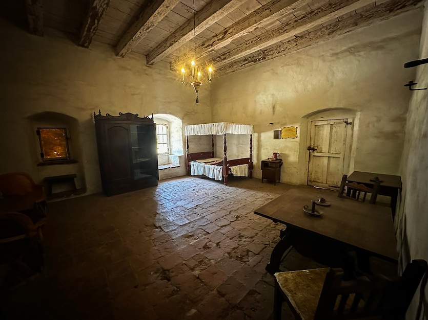
This room at Mission La Purísima is identical to the space that would have housed a Franciscan padre at the start of the 19th century. Photo by John Poimiroo
Mission La Purísima feels as if the padres and Chumash Indians just happen to be away, explains California State Park Ranger Leah Braitman, “Today, most missions are Catholic churches in an urban area. But this mission is an opportunity to see what an actual working mission would have looked like,” she smiles.
“A Mission was more than a church,” she continues. “Missions were huge enterprises that included vast holdings. Mission La Purísima extended as far north as Santa Maria and down to the ocean.
“California would be a different state today had the missions not introduced new plants, animals, and architectural styles. Though it was a blip in history – under a hundred years – the mission period transformed the state.”
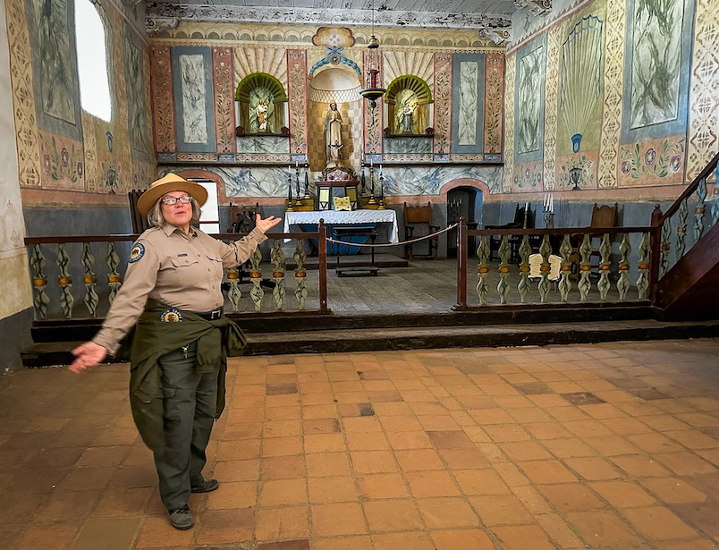
California State Park Ranger Leah Braitman escorts visitors around La Misión La Purísima Concepción De María Santísima or Mission of the Immaculate Conception of Holy Mary which was completed in 1787. Photo by John Poimiroo
“The missions are a way for us not to forget any of that history,” adds Jerry Edwards. “By traveling the trail, we get a better appreciation for all of that. We get to see things you don’t see flying by at 70 miles an hour. We get to appreciate the immensity of the state, what took place, how the missions were managed, and even before that, the rancherias, the areas where native-Americans lived and how they spent the entire day searching for food to support their families. And you get a real good sense traveling the trail what it was like for both groups.”
Says mission walker Kurt Buckley: “You may only ride or hike through a narrow swath of California, but your pace of travel will be similar to that of 250 years ago. Enjoy every moment and bond with the land. Hiking the trail or seeing it from a bicycle helps you realize the immense human effort that went into taming a wilderness and creating the agricultural economy that today coexists with the modern urban landscape.”
For Sandy Brown, the California Mission Trail “is a fabulous window onto the birth of the State of California. It will allow you to understand what California really is.”
And it’s all just the ring of a bell away … a bicycle bell.![]()